 rizky-amelia
Residents and tourists along Mexico's northern Pacific coastline are preparing for the imminent arrival of Hurricane Polo, a powerful Category 3 storm that forecasters expect to make landfall late Monday or in the early hours of Tuesday. The hurricane is projected to sweep across Baja California Sur, a state that draws large numbers of visitors each year and is home to the internationally known resort area of Los Cabos.
According to the US-based National Hurricane Center (NHC), Polo is currently packing maximum sustained winds of approximately 115 mph, equivalent to 185 km/h. That places it firmly within Category 3 territory on the Saffir-Simpson scale, a classification associated with devastating damage, including structural harm to well-built homes and widespread power outages that can last for days or even weeks after the storm has passed.
Meteorologists have issued stern warnings about the torrential rainfall that Polo is expected to dump on the region. The NHC cautioned that the downpours could trigger life-threatening flooding and mudslides, particularly in areas characterized by steep or mountainous terrain. Such landscapes are common across parts of Baja California Sur, where sudden runoff can turn normally dry gullies into fast-moving rivers of mud and debris, catching residents off guard.
Ahead of the storm's arrival on Sunday, people living in vulnerable communities flocked to shops and markets to stock up on basic necessities, including bottled drinking water and non-perishable food. The scene reflected a familiar pattern seen in hurricane-prone regions worldwide as families scramble to secure enough supplies to ride out several days without electricity, running water, or reliable access to grocery stores.
The NHC also warned about the potential for a dangerous storm surge generated by Polo, which could push seawater inland along the coast. That surge may be accompanied by large and destructive waves, capable of battering infrastructure, eroding beaches, and flooding low-lying neighborhoods. Storm surge is frequently cited as one of the deadliest hazards associated with tropical cyclones, often causing more fatalities than high winds alone.
In Cabo San Lucas, the town renowned for its dramatic natural rock arch, local authorities moved quickly to restrict access to beaches as a safety precaution. Several restaurants also shut their doors, according to reports. Cabo San Lucas serves as a hub for sport fishing and whale watching, two industries that depend heavily on calm seas and favorable weather, both of which have now been placed on hold indefinitely.
The regional government of Baja California Sur has ordered all schools to remain closed on Monday as a preventive measure. Governor Víctor Manuel Castro Cosío announced that temporary shelters had been opened in case residents need to be evacuated from their homes. The governor's statement signaled that officials are treating the approaching storm as a serious threat rather than a routine weather event.
Federal authorities have likewise mobilized significant resources, deploying thousands of navy and army personnel along with specialized machinery to assist with preparations and potential rescue operations. The presence of military units and heavy equipment suggests the government is anticipating possible infrastructure damage, blocked roads, and the need for rapid response in isolated communities once the storm moves through.
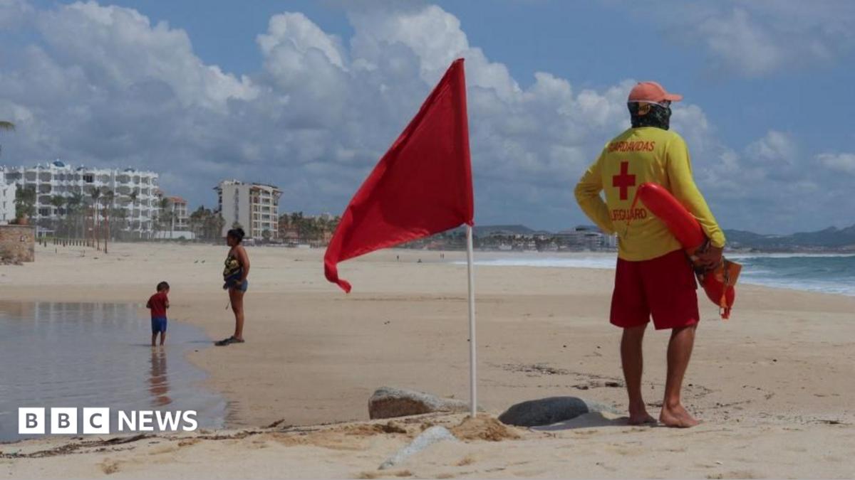
Lifeguards in Baja California Sur raised red flags along the beaches to alert holidaymakers to hazardous sea conditions. Photographs from the area showed lifeguards stationed beside the warning flags, a stark visual reminder that the ocean has become unsafe for swimming, surfing, or any other recreational activity. Red flags typically signify the highest level of danger, indicating that entering the water is strictly prohibited.
Polo has been moving gradually toward Mexico's coastline, giving forecasters and emergency managers additional time to track its path and refine their predictions. That slow forward motion, while providing extra notice, can also mean prolonged rainfall over a single area, exacerbating the risk of flooding and landslides as saturated ground gives way under the weight of accumulating water.
Meteorologists attribute the storm's remarkable strength to extremely warm ocean waters, a phenomenon linked to the El Niño climate pattern. El Niño, which involves periodic warming of sea surface temperatures in the central and eastern Pacific, can provide tropical cyclones with an abundance of energy, allowing them to intensify rapidly and maintain their power for longer periods than they otherwise might.
The El Niño connection is particularly significant given that forecasters recently noted that the developing El Niño has become the strongest on record weeks before its expected peak. That development raises broader concerns about how climate patterns may be influencing the frequency and intensity of severe weather events, not only in Mexico but across the Pacific basin and beyond. Warmer oceans are widely understood to act as fuel for stronger hurricanes.
It is worth noting that Polo's trajectory has been closely monitored for several days. Just four days ago, the storm was downgraded but remained described as "very powerful" off Mexico's coast, illustrating how quickly such systems can strengthen or weaken as they interact with atmospheric conditions and ocean temperatures. Earlier in the week, National Guard personnel were already moving along beaches in Acapulco, in Guerrero state, advising residents and visitors about the approaching storm.
For the resort communities of Los Cabos and surrounding areas, the arrival of a Category 3 hurricane represents a significant economic disruption as well as a physical danger. Tourism is the lifeblood of the region, and evacuations, beach closures, and business shutdowns carry financial consequences that can linger long after the skies clear. Hotels, restaurants, and tour operators must balance the need to protect guests with the imperative to safeguard property and equipment.
As Polo closes in, the next twenty-four to forty-eight hours will be critical. Emergency officials will be watching for changes in the storm's intensity and track, while residents in low-lying and flood-prone areas decide whether to remain at home or seek shelter. The coming days will determine not only the scale of the damage but also how effectively the region's preparations, from school closures to military deployments, have protected lives and livelihoods along Mexico's Pacific coast.







Comments (0)